
INDIAN ARMED FORCES CHIEFS ON
OUR RELENTLESS AND FOCUSED PUBLISHING EFFORTS

SP Guide Publications puts forth a well compiled articulation of issues, pursuits and accomplishments of the Indian Army, over the years

I am confident that SP Guide Publications would continue to inform, inspire and influence.

My compliments to SP Guide Publications for informative and credible reportage on contemporary aerospace issues over the past six decades.
Strategy
Plugging Gaps in Strategic MDA
Maritime events that could potentially affect India are not the only wide-ranging element of MDA but it is also essential that threats be identified as they evolve. The global nature of MDA activities occurring overseas and in foreign ports is very much a part of MDA. MDA must therefore be exercised over all oceans worldwide, and potentially cover all maritime interests that ultimately effect India.
Maritime Domain Awareness is “the effective understanding of anything associated with the global maritime environment that could impact the security, safety, economy or environment of the United States. This is accomplished through the integration of intelligence, surveillance, observation, and navigation systems into one common operating picture (COP) that is accessible throughout the US Government.”
The oceans are comple x mediums whose nature provides ample opportunity for an enemy to avoid detection—weather, sea states, and coastal land mass, all present considerable challenges to modern sensors. Peacetime economic use of the seas complicates this problem enormously. The oceans are the world’s foremost (and most unregulated) highway, home to a vast and wide variety of international neutral shipping that possess no apparent threat. Determining the enemy in such a crowded and complex environment is difficult during conventional war, but during an asymmetric conflict such as the global war on terror, it is a formidable task. Oceans demand a much higher level of awareness than that is normally required in a conventional naval conflict. This is recognised by the formal definition of Maritime Domain Awareness (MDA) as articulated by the US Government vide their definition of MDA quoted above.
It is apparent that the goal of MDA is far more than simply looking for potential maritime enemies poised to attack India. The implications of “Anything associated” with the maritime environment that can influence the security, safety, economy, or environment” go far beyond a classic maritime threat. As per the US interpretation, these include smuggling of people or dangerous cargoes, piracy, proliferation of weapons of mass destruction, identification and protection of critical maritime infrastructure, oil spills, weather, and environmental concerns among other events.
Maritime events that could potentially affect India are not the only wide-ranging element of MDA but it is also essential that threats be identified as they evolve. The global nature of MDA activities occurring overseas and in foreign ports is very much a part of MDA. MDA must therefore be exercised over all oceans worldwide, and potentially cover all maritime interests that ultimately effect India. Putting in place an effective MDA is a herculean task viewing the range of potential security challenges and enormous geographic area represented by the maritime domain. MDA’s core is applying the vessel tracking process to a layered defence model centred on the coastline of India, the ultimate goal of which is to detect potential threats as early and as far away from the Indian coastline as possible. As there is no single high value unit to protect, MDA “layers” are expanded to include an entire coastline with the overall goal of coordinated surveillance. Not all areas in these “layers” are considered equally, but rather additional attention is given to areas that are potential targets for the terrorist/enemy.
Gaps in Strategic MDA. MDA’s goal is to obtain a sense of global awareness that reaches beyond the confines of the tactical and regional levels. If MDA was simply a defensive strategy against a known military or terrorist threat, it could be obtained by forming defensive layers around India. However, as an informational/awareness system, its goals are far broader, seeking to understand all potential maritime threats to India, many of which could originate overseas in an inoffensive manner. Strategic MDA requires a broad perspective and capabilities at the highest levels of analysis, intelligence, and policy. The Government of India has put in place a formidable plan for MDA, and the individual systems are being set up prior to final integration and fusing of data. It is expected that the MDA would be fully functional in a year or so. However, a broader oceanic horizon needs to be factored in while acquiring futuristic technological capabilities. This should be inclusive of not only extensive and broader spatial operating arena, but also much wider and intensive foray into the verticals below the surface to the sea bed and above up to periphery of the atmosphere. Unless implications of this nature are anticipated and factored in, technological forecasts themselves would trail behind the rapid advancing pace of technology and the synergies being achieved due to harmonisation and adaptation inter and intra scientific fields. Therefore, it is imperative that holistic perspectives into the information consciousness arena include the oceanic domain awareness as well as its connect with India’s security and MDA.
The Government of India has put in place a formidable plan for MDA, and the individual systems are being set up prior to final integration and fusing of data
The coast and Open Ocean are critical domains for the security of a nation with sea as boundaries, both at home and abroad. National-security operations in the ocean take place globally and often require continuous, near real-time monitoring of environment using tools such as autonomous sensors, targeted observations, and adaptive modeling. These capabilities, combined with improved understanding of the ocean environment enabled by other ocean science research activities, will support accurate ocean-state assessments and allow future forces to conduct joint and combined operations in near shore and deep-ocean, anywhere and at anytime.
Thus, it can be surmised that currently the MDA focuses upon the maritime security scenario specific to naval operations; there is a need to look into the overarching oceanic environment. This would require sophisticated sensors and computational capabilities. There is therefore a requirement to fuse the tactical, and regional components with strategic knowledge-based architecture.
This expansion will require advancing sensor and technology capability and/or development, particularly for autonomous and persistent observations. Data collected by the observing systems must be accessible through a comprehensive national data network, through either a single system or a distributed network. Developing this data network will require new methodologies that address gaps in data collection, sharing, and interoperability of technologies, and should permit integration of existing research into operational systems.
Technology Perspective
Asia-Pacific is a vast region and therefore data generation and collection is a humongous and costly task. The coverage and resolution provided by manned resources and satellites remains grossly deficient considering the large area, time needed, and multitude of tasking requirements. This gap can be plugged by utilising the autonomous aerial, surface and underwater systems. These could provide persistence, mobility, and real-time data. The manned systems could thereafter be deployed more selectively.
“…[t]he main advantage of using drones is precisely that they are unmanned. With the operators safely tucked in air-conditioned rooms far away, there’s no pilot at risk of being killed or maimed in a crash. No pilot to be taken captive by enemy forces. No pilot to cause a diplomatic crisis if shot down in a ‘friendly country’ while bombing or spying without official permission.”
In essence, the autonomous unmanned systems provide the advantages of large area coverage, prolonged deployment, low risk, much lower acquisition and operating costs, direct tasking and near real-time data reporting. In case of surface and underwater systems however the transit times are higher than the Aerial systems.
Aerial Systems
Lockheed Martin High Altitude Airship. The Lockheed Martin High Altitude Airship is an un-tethered, unmanned lighter-thanair vehicle that is being designed to operate above the jet stream in a geostationary position to deliver persistent station keeping as a surveillance platform, telecommunications relay or a weather observer. It will provide the military with ever-present ISR and rapid communications connectivity over the entire battle space. The airship is estimated to survey a 960-km diameter area and millions of cubic miles of airspace.
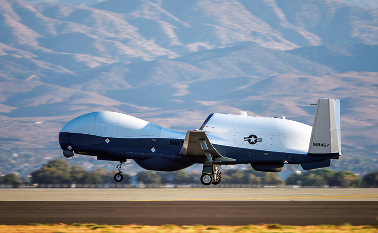
Global Hawk and Triton MQ-4C. Global Hawk is the long-range, high-altitude ISR unmanned aerial system (UAS) of the US Air Force manufactured by Northrop Grumman. It can fly for up to 32 hours at altitudes as high as 60,000 feet, with a range of 12,300 nautical miles, providing imaging and signals intelligence, as well as communications support, to troops around the world. The US Navy has Triton MQ-4C UAV of Northrop Grumman which is build on elements of the Global Hawk and developed under the Broad Area Maritime Surveillance programme. It can stay aloft for over 24 hours at 17,000 m. It has speeds of up to 610 kmph. Its surveillance sensor is the AN/ZPY-3 Multi-Function Active Sensor (MFAS) X-band active electronically scanned array radar with a 360-degree field-of-regard, capable of surveying 70,00,000 sq km of sea.
Sensors Packages. The ARGUS-IS is a Defense Advanced Research Projects Agency (DARPA) project contracted to BAE Systems and is a type of of wide-area persistent surveillance system. It is a camera system that utilises hundreds of mobile phone cameras in a mosaic to video and auto-track every moving object within a 95-sq-km area. ARGUS-IS provides military users an “eyes-on” persistent wide area surveillance capability. The system streams a million terabytes of HD video per day. The enormous amount of data can be stored indefinitely and subjected to review as and when required. It is understood that ARGUS can be easily deployed on UAS. The software utilised by ARGUS-IS is Persistics developed by Lawrence Livermore National Laboratories. It is a data compression programme, which can compress the raw wide area video data from aircraft and UAVs by 1,000 times and achieve a reduction of preprocessed images by a factor of ten.
Autonomous Surface and Subsurface Vehicle (ASV). ASV unmanned Marine Systems of UK manufacturer C-Enduro, which is a long endurance autonomous surface vehicle, used to safely and cost-effectively collect data at sea. Built to operate in all marine environments, C-Enduro uses energy harvesting technology combined with a self-righting hull. It can house different sensor packages like keel mounted sensors, CTD lowered by winch, meteorological sensors, acoustic doppler current profiler, multi beam echo sounder, sidescan sonar, acoustic modem, anti-submarine warfare (towed array or dipping), and electronic warfare.
Thales is involved in the Defence Science Technology Laboratory (DSTL) research programme MAPLE (Maritime Autonomous Platform Exploitation). The MAPLE programme is developing the future architecture for UAS’ command and control, by enabling multiple unmanned platforms, such as UAV, unmanned surface vehicles and unmanned underwater vehicles, and their payloads to be innovatively commanded and controlled from a single control station.
Wave Gliders. Due to their unique design wave gliders provide advantages of; indefinite, long-range mission endurance; all weather operations; unlimited ocean area coverage; real-time data acquisition; multiple sensor payloads; low acquisition and operating costs, and autonomous operation. The main manufacturer is liquid robotics. One of liquid robotics wave glider, the SHARC is designed to meet unique requirements of defence and national security applications. Over 200 wave gliders have been delivered internationally.
The use of autonomous systems for MDA is an imperative for India. However, it would also be important for military officials to make sense of the vast amount of data that is being generated
The principle of operation of ocean gliders involves small changes in buoyancy and wings to achieve forward motion. Control of pitch and role is done by adjusting ballast. It uses GPS as well as internal sensors for navigation. It can travel thousands of miles at depths of up to 1,000 metres. There are three established manufacturers of sea gliders, namely iRobot who make Seaglider, Teledyne Webb manufacture Slocum Glider and Bluefin Robotics who make Spray Glider. ACSA, a French glider firm, has recently launched the SeaExplorer, a streamlined, wingless glider. A glider called Sea Wing, has been developed at the Shenyang Institute of Automation, in China, by Yuan Dongliang of the country’s Institute of Oceanography. It was tested last year and operated successfully in the western Pacific at depths of up to 800 metres. Japanese researchers, too, are building gliders. One is a small, low-cost version called ALEX that has independently movable wings and the other is a solarpowered device called SORA.
Data Analytics. The use of autonomous systems for MDA is an imperative for India. However, it would also be important for military officials to make sense of the vast amount of data that is being generated. A simple full-day UAV mission can provide upwards of 10 terabytes of data of which only about five per cent is analysed and the rest stored. Currently, analysts are restricted by the download speeds of data depending upon their locations. Untagged data leads to downloading of similar data from other sources by the analyst to firm up their conclusions. ISR data from different sources is stored in different locations with varying access levels, this leads to incomplete analysis. Single network domain providing access to data at multiple levels of security classification is not yet available. This is leading to a synergetic relationship with digital industry where in military no longer develops its own hardware and software denovo, but harnesses and modifies the ‘commercial of the shelf’ (COTS) items. Some common technologies in the data analytics ecosystem are Apache Hadoop, Apache Hive/Apache Pig, Apache Sqoop, In-memory Databases, NoSQL Databases and MPP Platforms. Some of the firms working in this space with the military are Palantir, Sap, Oracle, Teradata, and SYNTASA. Security of collected and processed data also would require adequate attention, this could be dovetailed with the cyber defence effort of the armed forces.
Major gaps in the Indian MDA infrastructure can thus be plugged by the use of autonomous systems along with the associated data analytics and data protection platforms.
SP's Naval Forces - CURRENT ISSUE